Dutch Caribbean Islands (BES)

The islands of Bonaire, Sint Eustatius and Saba (BES islands) are a group of islands that are part of the Caribbean Netherlands, with a special municipality status. These islands are famous for their unique landscapes and coastal ecosystems. However, they are also subject to various natural hazards that pose serious risks to the environment, infrastructure and the safety of the local populations.
A significant natural hazard that these islands experience are hurricanes. Located in the hurricane belt, the BES islands are vulnerable to tropical cyclones that form in the Atlantic Ocean during the hurricane season between June to November. Hurricanes are a destructive force of nature, bringing in heavy rainfall, high wind speeds, storm surges, coastal and inland flooding. These hazards can damage critical infrastructures and threaten the safety and well-being of local communities. As small islands with highly exposed coastlines, other coastal hazards such as erosion and sea level rise can result in loss of beaches and coastal habitats, as well as threaten freshwater resources due to salinization. The low-lying nature of the island makes them more susceptible to such hazards. Under climate change, these islands remain more vulnerable than ever, and will require adaptation measures to protect the coastal environment and communities.
As the BES islands hold a special municipality status, the Water Management Centre of the Netherlands (WMCN) is tasked with the responsibility of providing timely hydro-meteorological information for these group of islands. Within this project, WMCN is an end-user that interfaces with the local BES authorities. Currently, there are no existing forecasting infrastructures in-place.
User

The Water Management Centre of the Netherlands (WMCN – Watermanagementcentrum Nederland) within Rijkswaterstaat (agency under the Dutch Ministry of Infrastructure and Environment) is the knowledge and information centre for the Dutch water system. Dutch water managers work at the regional and national level within the centre and aims to contribute towards uniform and optimal management of the Dutch water system. By collaborating together with the Dutch Meteorological Institute (KNMI), regional water boards, provinces, security regions and knowledge institutes, WMCN leverages this platform to be able to perform its duties to the best of their abilities and available knowledge.
The Water Management Centre of the Netherlands (WMCN – Watermanagementcentrum Nederland) within Rijkswaterstaat (agency under the Dutch Ministry of Infrastructure and Environment) is the knowledge and information centre for the Dutch water system. Dutch water managers work at the regional and national level within the centre and aims to contribute towards uniform and optimal management of the Dutch water system. By collaborating together with the Dutch Meteorological Institute (KNMI), regional water boards, provinces, security regions and knowledge institutes, WMCN leverages this platform to be able to perform its duties to the best of their abilities and available knowledge.
Contribution to the DE370A_Deltares project
Aside from sitting in the hurricane belt, the BES islands will continue to be more vulnerable in the future under the impacts of climate change, such as increased frequency and intensity of extreme events and with sea level rise. KNMI currently has a hazard platform (https://www.knmidc.org/weather/) for weather, aviation and seismology for the BES islands. A generic model workflow for hydrology and coastal hydrodynamics and flood impacts will be applied under forecasting mode. Hereto re-forecast data will be provided by KNMI from there HARMONIE model for storm Tammy (2023). Deltares will derive flood impact maps that can be displayed in the KNMI dashboard for the BES Islands.
Local Digital Twin Implementation
The model chain for the BES Islands includes a sub-selection of models from the full DestinE Modelling Framework (see Figure 5‑2).
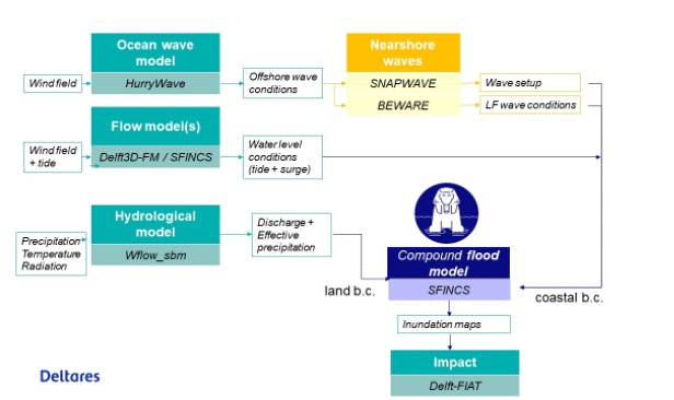
We implemented wflow_sbm for the entire island and SFINCS for the coastline (see Figure 5‑3).

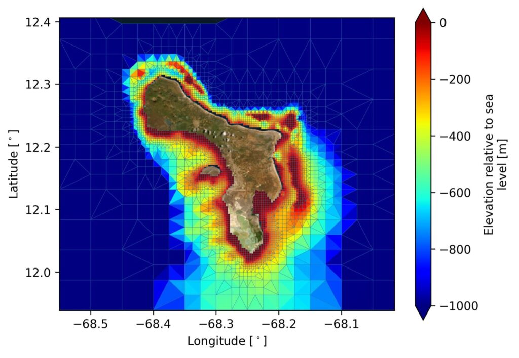
The SFINCS model takes river discharge from wflow_sbm as upstream river boundary conditions and water levels from Delft3D-FM as coastal boundary conditions (see Figure 5‑3 and Figure 5‑4). Hereto a local Delft3D model (Figure 5‑5) was implemented for the ocean around Bonaire to downscale the GTSM simulations to the coast.
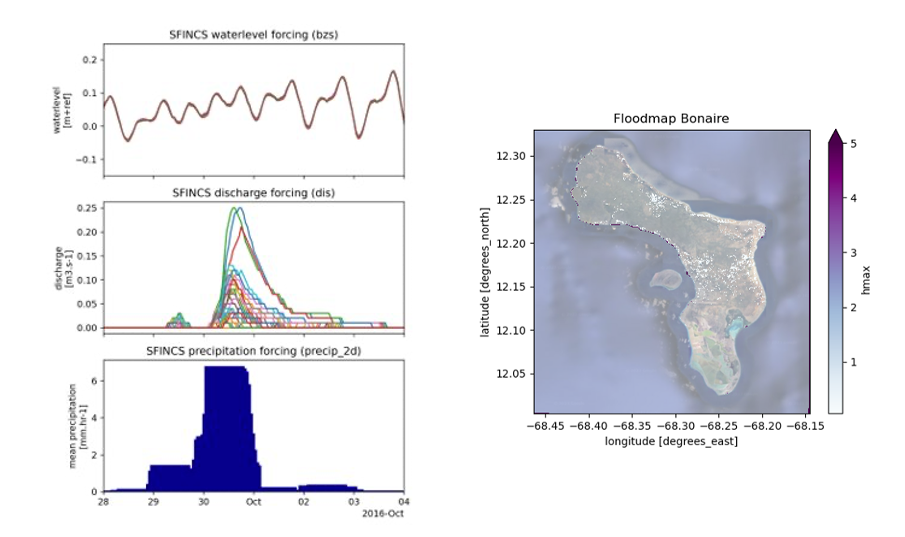
First simulations were run for cyclone Matthew (2016) based on ERA5 data. In the next phase we will work with higher resolution re-forecasts from the Numerical Weather Prediction model HARMONIE. The data will be provided by KNMI for storm Tammy (2023). We will implement a Delft-FIAT model to assess damage. The resulting flood impact maps will be loaded in the dashboard for the BES-Islands that is in place at KNMI.
Partners
The Royal Netherlands Meteorological Institute (KNMI) is the national research and information centre for weather, seismology, climate and climate change in The Netherlands. With its long tradition in operational and scientific activities, the climate research undertaken at KNMI aims at observing, understanding and predicting changes in the climate system. KNMI offers products and services that contribute to the safety, accessibility, sustainability and prosperity of the Netherlands. Within this project, KNMI will be responsible for the data interface to the BES islands. KNMI, WMCN and Deltares have a long and strong history of collaboration on flood forecasting, river management and climate adaptation for the Netherlands.