CITYNEXUS: Redefining urban planning through advanced data-driven solutions
In the dynamic landscape of Copenhagen’s urban planning, the CITYNEXUS Use Case emerges as a pioneering tool, offering new methods for decision-making through predictive modelling. This modelling draws from a rich combination of location-based mobility data, extensive local datasets, paired with the advanced functionalities and data of DestinE.
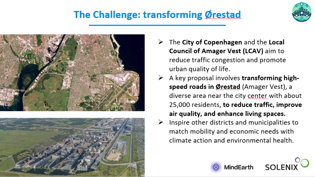
This innovative application aims to assist the Local Council of Amager Vest and the community of Ørestad in planning for a more liveable city for all its citizens by integrating cutting-edge simulation technology with comprehensive insights into sustainable development strategies.
How does it work?
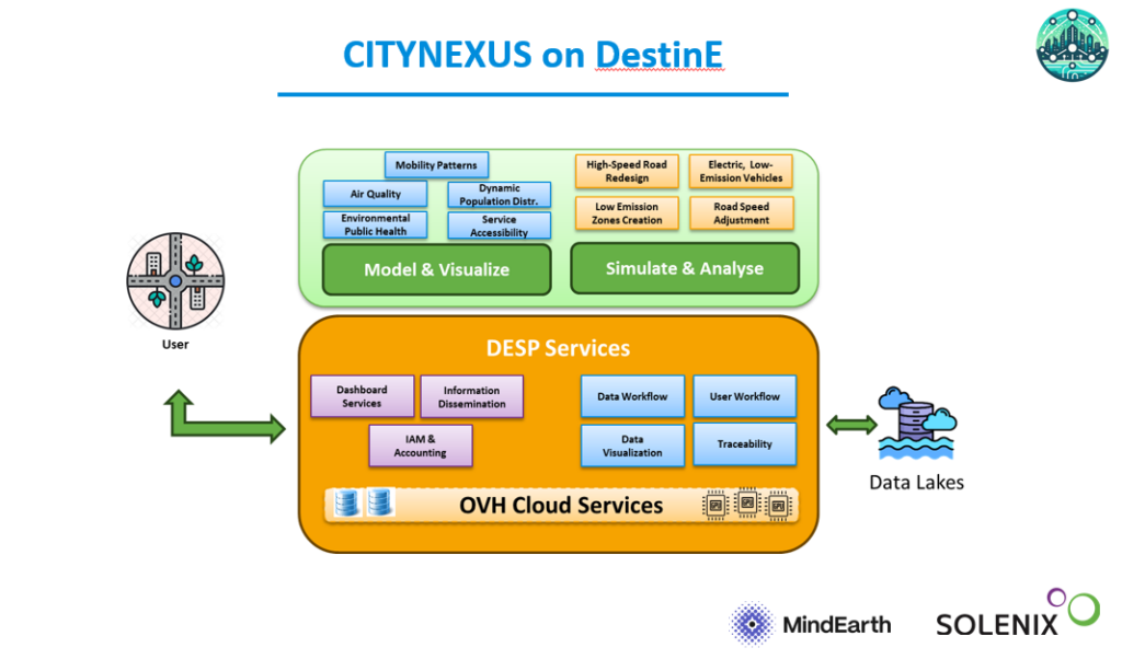
CITYNEXUS enriches the DestinE Platform with sophisticated data analytics and simulation capabilities tailored for urban environments. Central to its functionality is the integration of diverse datasets from multiple sources, including location-based mobility records for dynamic population mapping, Sentinel-5P TROPOMI for air quality monitoring, ECMWF’s ERA5 for weather patterns, Copernicus DEM for terrain modelling to cite a few.
This data tapestry lets CITYNEXUS conduct detailed spatial analyses and predictive modelling, crucial for assessing the impacts of urban development initiatives on human mobility and environmental pollution.
The application employs visualisation tools to render complex data into intuitive, actionable insights. Users can interact with dynamic maps, graphs, and 3D models that visualise in a simple and intuitive way the potential outcomes of various scenarios. For instance, stakeholders can explore how changing the road infrastructure, adding new points of interest (such as shops, cafés, restaurants), restricting traffic to low-emission vehicles only or setting speed limits affects traffic flow, air quality, and public health indicators across different neighbourhoods.
The platform’s user interface is designed for ease of use, with drag-and-drop functionalities and customisable dashboards that allow users to focus on specific areas of interest. In this way, by interacting directly with the system via 2D and 3D maps, slides, pop-ups and more, users can manipulate specific parameters, visualise introduced changes and explore correlations between different factors such as traffic patterns and pollution levels. This level of visual detail enhances both the accessibility of information and the depth of prediction capabilities for informed decision-making.
What will CITYNEXUS offer?
CITYNEXUS encompasses a wide array of parameters essential for urban planning and policy formulation. These include:
- Mobility Patterns: Analysis of traffic flow, pedestrian movement, and public transport usage to optimise transportation networks and reduce congestion.
- Air Quality: Monitoring pollutants and emissions to assess environmental impacts and support initiatives for cleaner air.
- Points of interest: By indicating where these are distributed, the model can make better predictions on citizen mobility related to different types of drivers (i.e. work, school, leisure, dinner out and more).
- Population changes: By increasing or reducing population in specific areas, the model can adjust the mobility demand generated.
- Specified Timeslots: the system allows to model mobility and air quality patterns hour by hour for a typical working day and weekend day, helping users to capture different mobility trends observed at multiple moments of the day.
The data collection process for CITYNEXUS is meticulously curated, combining historical mobility records and pollution concentration patterns to generate accurate predictive analytics.
Automated data feeds from environmental monitoring stations, mobility data, and satellite imagery populate the platform’s database, to generate accurate simulations and scenario analyses, providing a robust foundation for evidence-based policymaking and strategic planning.
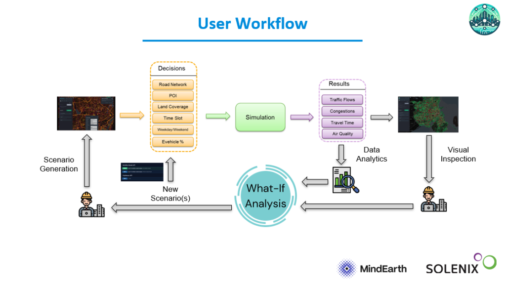
As CITYNEXUS uses machine learning algorithms to process and analyse the collected data, it can identify patterns and trends that might not be immediately apparent. For example, it can reveal different infrastructure development options may impact mobility or air quality in areas far away from where the change occurred, offering deeper insights into urban dynamics.
Additionally, CITYNEXUS ensures that the decision-making process is transparent, allowing users to test individual changes to understand their impact. This ability to forecast outcomes allows for more strategic and proactive urban planning, reducing the risk of unintended consequences and ensuring that initiatives align well with broader sustainability goals.
Users of CITYNEXUS on the DestinE PlatformSelf-standing DestinE system component, interfacing with the More have a variety of functionalities to play with at their disposal. Urban planners can experiment with different land use scenarios, adjusting parameters such as road configurations, concentration of point of interests and new traffic regulations. Policymakers can assess the trade-offs between various development options, balancing mobility demands with environmental sustainability, guided by insights into how each decision impacts community well-being and urban resilience. Community engagement is crucial for such a project, which is why CITYNEXUS maintains a strong connection with the local stakeholders of Amager Vest and the City of Copenhagen.
Beyond the Use Case
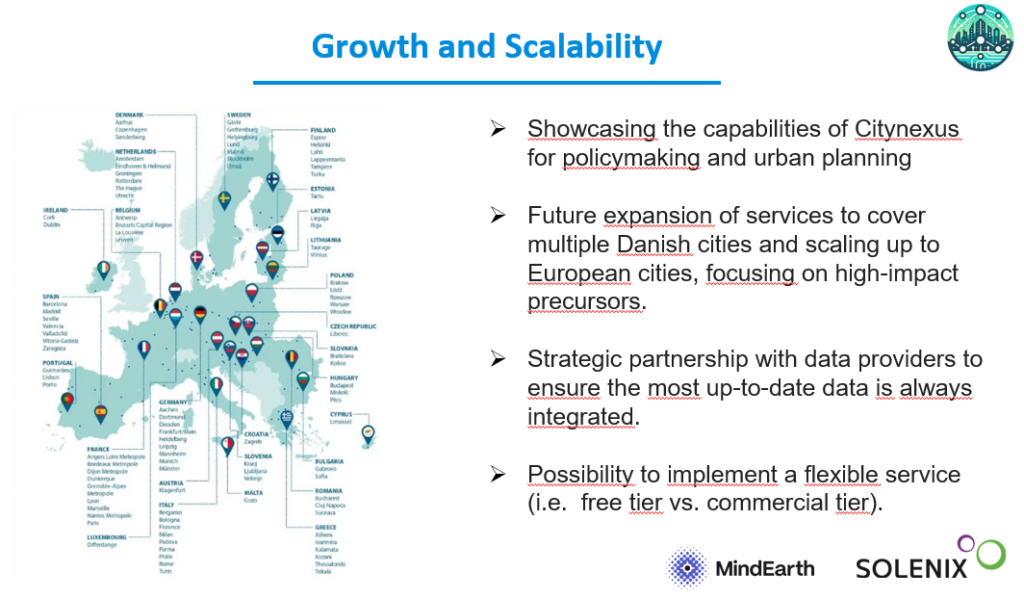
Beyond Copenhagen, CITYNEXUS sets a precedent for collaboration in urban sustainability. By aligning with international frameworks like the EU’s 100 Climate-Neutral and Smart Cities by 2030 initiative under the DestinE initiative, CITYNEXUS amplifies the platform’s impact and positions DestinE as a leader in promoting sustainable urban development through data-driven innovation.
By demonstrating the tangible benefits of using advanced analytics and visualisation tools for urban development, CITYNEXUS aims to create a ripple effect, encouraging cities globally to embrace digital transformation and sustainable development practices. Through advanced analytics, comprehensive data integration, and intuitive visualisation tools, the project will empower cities to navigate complex urban challenges while advancing towards sustainable, resilient futures.
As cities embrace digital transformation, CITYNEXUS will be one of the pioneers of the new collaboration for urban development, paving the way for smarter, greener, and more inclusive urban environments globally.
Want to learn more? You can watch the recording of the CITYNEXUS Roadshow Webinar now!