Four new services on DestinE

In 2025, Destination Earth (DestinE) launched an open call for new services on the DestinE Platform. The goal was simple: to find new services to expand the DestinE ecosystem and ensure the platform’s portfolio is diverse.
Since then, 12 service providers have been selected to deliver apps and services on the DestinE PlatformSelf-standing DestinE system component, interfacing with the More, with four of these already available. They are Hi-Res LST, HARVIC, COMEO and CALIFE. Learn more about each service:
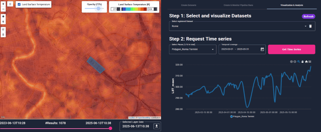
Hi-Res LST: sharper views of surface heat
Hi-Res LST puts detailed land surface temperature data at your fingertips. It combines Sentinel-3 data at 1 km spatial resolution with a high-resolution land surface temperature product from Landsat-8. This lets you see urban areas in much finer detail down to 30 metres, something Sentinel-3 alone cannot offer.
You start by creating an area of interest you want to explore, then register a pipeline run. This will deliver the land surface temperature data you request within your chosen time window. Once the run is complete, you can explore the results in an interactive visual setup.
The 30-metre resolution is especially useful if you want to study how land surface temperature changes over time in cities. The service includes thermal products starting from 1 June 2018. If you would like to try it but are not sure where to begin, check the tutorial.
HARVIC: tracking potato crops
HARVIC was designed for stakeholders in the potato industry. The service combines satellite information, weather data and field observations to estimate crop development throughout the season. It also predicts harvest timing and helps users estimate the size of the harvest.
As of now, the service lets users select predefined fields and see how crops developed throughout their usual growth season in 2023. This showcases what the service can do, as well as what the dashboards look like. The list of fields will be adapted soon with insights for 2024 and 2025. HARVIC will also include fields in Germany, Belgium and France and could be particularly useful for companies that manage hundreds of fields at the same time.
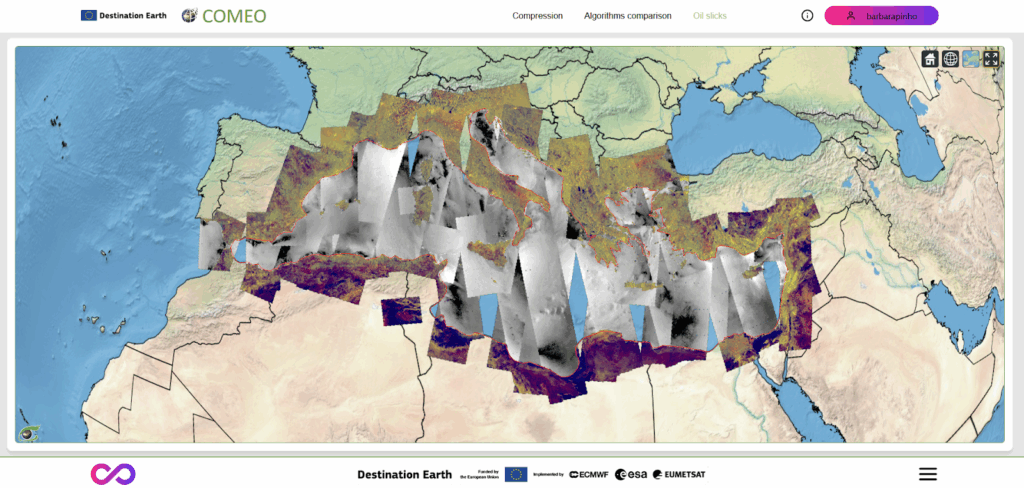
COMEO: making massive datasets manageable
COMEO is DestinE’s latest data compression service. It compresses Sentinel-1, Sentinel-2 and ERA5 datasets using lossy algorithms to reduce file sizes by a factor of 10 to 250. This means you can work with extremely large Earth observation and climate datasets without requiring vast storage capacity or bandwidth.
COMEO’s documentation outlines the datasets supported by COMEO and provides guidance on how to prepare and download compressed products.
The service also includes a demonstration tool that lets you see the impact of lossy compression for yourself. The demo showcases 213 Sentinel-1 products compressed using JPEG2000 (with a compression factor of 20) over the Mediterranean sea, focusing on oil slick detection. Some images are stored in cache while the full-resolution levels are decompressed on demand. Thanks to COMEO’s lossy compression, the full dataset occupies around 23 gigabytes instead of the 340 gigabytes uncompressed.
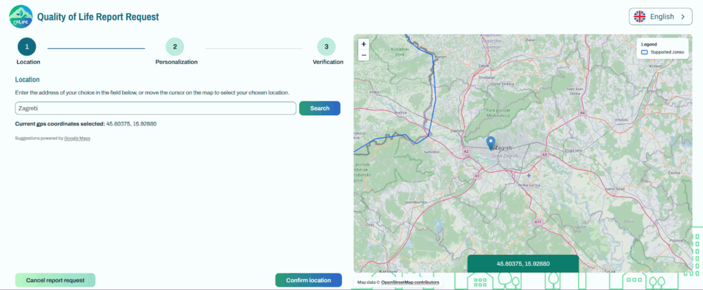
CALIFE: local insights for healthier living
CALIFE lets you create reports that assess your quality of life, based on where you live. It then guides you through actions you can take to improve your surroundings and enjoy a healthier lifestyle. The service covers EU Member States, the United Kingdom, Switzerland and Norway. You can generate a report in English, French or Spanish and explore six topics: health, transportation, weather, water, green spaces and hazards.
When it comes to health, the report looks at how close you are to a healthcare facility and at air pollution indexes. The transportation variables assess options for both long-distance travel and daily local mobility. You can find more details on each variable in the service’s documentation.
Each report also includes projections of extreme events that might affect your area. These are not certainties about what will happen in the future. Still, they can help you prepare and safeguard your home. If you work in a local NGO or a municipality, the report can help you see which regions might need more support. You can use it to decide where to focus your work and plan ahead to make your city more resilient to a changing climate.
At the end of the day, seeing is believing, so visit the DestinE PlatformSelf-standing DestinE system component, interfacing with the More and create your own report now. Every user can generate three reports, but if you need more, contact the team at contact@murmuration-sas.com.
Over the coming weeks, we will be introducing you to the eight new services that will soon be joining the DestinE PlatformSelf-standing DestinE system component, interfacing with the More. Make sure you subscribe to the newsletter so you don’t miss out!