Mapping the future of Marine Conservation with DestinE’s Global Fish Tracking System
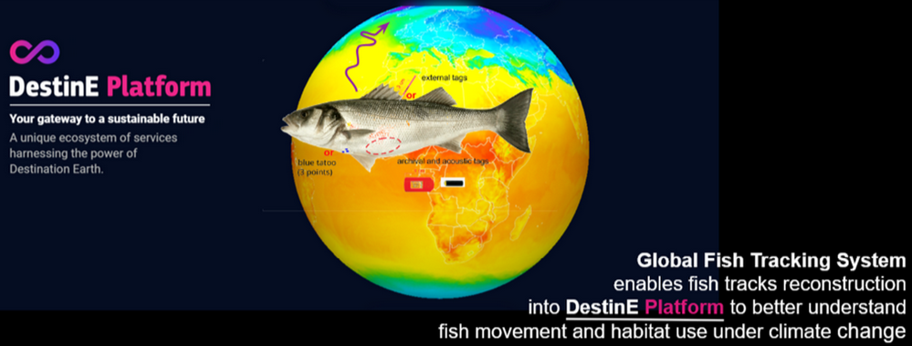
In a world increasingly threatened by climate change, the need for innovative solutions to preserve our ecosystems has never been more urgent. The Global Fish Tracking System (GFTS) is a use case within the DestinE (Destination Earth) framework that stands out as a promising effort in marine conservation.
The vision behind GFTS is straightforward: to make fish tracking estimates more accessible and usable for a broader audience, especially those involved in scientific research and policymaking. The goal of GFTS is to help scientists with biologging data to estimate fish tracks and cross-reference current fish locations with current and future human marine activities and future environmental conditions. This capability is crucial as it enables scientists to better understand the dynamics of fish populations which is essential when analysing the changing environmental conditions they are going to experience. This will provide invaluable insights for future conservation efforts.
One of the primary challenges that GFTS addresses is the complexity and scale of data involved in fish track modelling. Traditionally, biologging data related to fish tracking has relied on cooperation and shared storage through systems such as that of the European Tracking Network. However, no track reconstruction system from combined data storage tags and acoustic telemetry data was made available to the community. This has made it difficult to apply it effectively in conservation strategies. GFTS, however, offers a solution by providing a centralised platform where this data can be gathered, analysed, and used in a more streamlined and efficient manner.
At the heart of the Global Fish Tracking System lies a sophisticated combination of data aggregation, modelling, and estimation, all made possible thanks to the data and calculation capabilities of DestinE’s digital twin technology. The technical functioning of GFTS is built upon several core components that work in tandem to deliver precise and actionable insights into fish movements and habitat use.
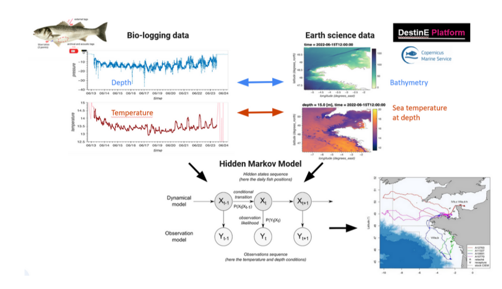
GFTS uses biologging data collected from various sources such as acoustic telemetry and data storage tags that record temperature and depth. These data points, often vast and varied, are uploaded into the system where they undergo a series of processing steps. The first crucial step involves cleaning and standardising the data to ensure consistency, which is vital given the diversity of data sources.
Once standardised, the data feeds into the GFTS’s modelling engine. This engine leverages advanced algorithms that reconstruct fish trajectories using a hidden Markov model framework. This framework allows inference of fish hourly or daily positions by combining a movement model with an observation model [Pedersen et al 2008]. For GFTS, the temperature and depth sensor records are related to ocean temperature data to determine the most probable fish location. The model is probabilistic and incorporates a level of uncertainty, generating hourly or daily posterior distribution of fish presence, from which summary tracks can be derived. A geolocation model based on temperature and depth data was previously developed for tracking European seabass by members of the consortium [Woillez et al. (2016)]. In GFTS, this model was adapted to integrate acoustic detections in addition to temperature and depth records [Goossens et al. (2023)].

These models are integrated with DestinE’s climate adaptation digital twin, which provides simulations of sea temperature fields. This digital twin replicates physical and biological processes with a degree of detail that allows GFTS to first use these geophysical reference fields to estimate fish tracks and second cross-reference the modelled fish tracks with future oceanographic conditions. For example, as the digital twin simulates changing sea temperatures under various climate scenarios, GFTS can estimate what would be the environmental conditions fish will experience in the future under different climate scenarios.
The DestinE PlatformSelf-standing DestinE system component, interfacing with the More offers a centralised hub where produced digital twin data can be accessed, algorithms can be run, analyses conducted, and results presented—all within a cohesive environment. This level of integration is essential for managing the complex data that underpins GFTS, ensuring that it is not only manageable but also useful for the scientific community and policymakers who depend on accurate and timely information.
The implications of GFTS extend far beyond mere data accessibility. By bringing together diverse biologging data sources and modelling capabilities, GFTS has the potential to unite the biologging science community around a common goal: the preservation of marine life in the face of climate change.The use case aims to bring together the biologging community around this system and make their work easier, and through that, hopefully create positive dynamics and bring more users to GFTS.
This collaborative approach is particularly significant when considering the global nature of the challenges at hand. Marine ecosystems are interconnected, and the impact of climate change on one species or habitat can have far-reaching consequences across the oceans. By facilitating a more coordinated and comprehensive approach to fish tracking and conservation, GFTS could play a crucial role in enhancing the resilience of marine ecosystems worldwide.
While GFTS does not simulate fish movement in real-time, it reconstructs historical fish movements based on biologging data and historical environmental conditions. Scenarios include the assessment of possible interactions between future developments of human marine activities (e.g. offshore wind farms) and the assessment of environmental conditions that fish will experience in the future. This method provides valuable insights for fishery management too, allowing for the identification of critical habitats and an understanding of how fish populations might shift in response to environmental changes providing that the fish are monitored over the years and generations. Such insights are essential for developing spatial management strategies that promote sustainable fishing practices and protect vulnerable species.

Looking to the future, the team behind GFTS sees enormous potential for the project to expand and evolve and is more than optimistic about its relation with DestinE. There is a clear ambition to attract more scientists to the GFTSand to broaden its modelling capabilities to include various fish species across different regions of the world and include new model capabilities, for instance by doing light-based geolocation. By demonstrating the DestinE Platform’s versatility and effectiveness, GFTS aims to foster a dynamic community of users who can collectively contribute to the long-term sustainability of marine ecosystems.
The Global Fish Tracking System represents a significant advancement in our ability to understand and protect marine life. As this innovative project continues to develop, it holds the promise of transforming not only how we manage our oceans today but also how we safeguard them for future generations.
Make sure you don’t miss important DestinE updates.
References:
Goossens, J., Woillez, M., LeBris, A., Verhelst, P., Moens, T., Torreele, E., & Reubens, J. (2023). Acoustic and archival technologies join forces: A combination tag. Methods in Ecology and Evolution, 14(3), 860–866.
Pedersen, M. W., Righton, D., Thygesen, U. H., Andersen, K. H., & Madsen, H. (2008). Geolocation of North Sea cod (Gadus morhua) using hidden Markov models and behavioural switching. Canadian Journal of Fisheries and Aquatic Sciences, 65(11), 2367–2377.
Woillez, M., Fablet, R., Ngo, T.‐T., Lalire, M., Lazure, P., & de Pontual, H. (2016). A hmm‐based model to geolocate pelagic fish from high‐resolution individual temperature and depth histories: European sea bass as a case study. Ecological Modelling, 321, 10–22.
