UrbanSquare: transforming urban planning through climate resilience
In the ever-evolving landscape of urban development, the UrbanSquare Use Case emerges as a revolutionary tool for urban planners, offering new methods for integrating climate resilience into city planning.
The Use CaseA practical scenario in which DestinE's capabilities are uti More harnesses a rich combination of satellite imagery, digital twin technology, and extensive local datasets, all enhanced by the robust functionalities and data provided by Destination Earth (DestinE). This innovative application aims to support municipalities and urban planners by providing comprehensive insights and simulation tools to create more sustainable, resilient, and liveable urban environments.
How does it work?
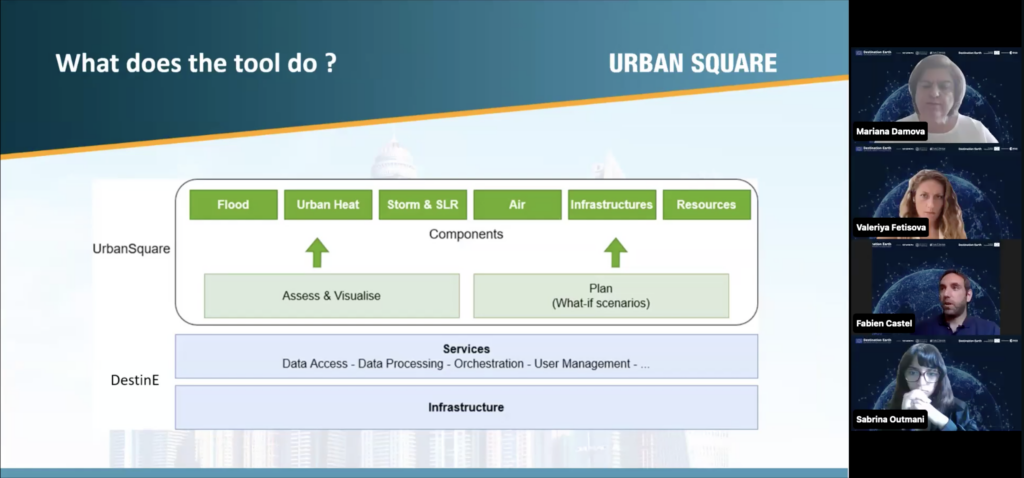
UrbanSquare is conceived to address the pressing need for urban areas to become more resilient to climate risks. With increasing population densities and urbanisation in areas prone to climate impacts, urban planners require sophisticated tools to prioritise climate resilience. UrbanSquare offers such a tool, providing comprehensive data on various climate risks, including floods, sea level rise, air quality, heat waves, infrastructure damage, and resource scarcity.
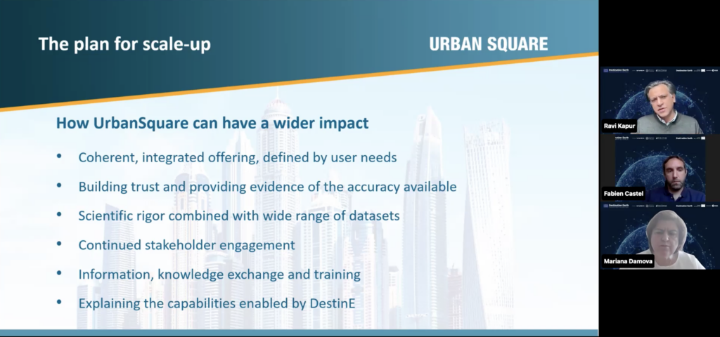
DestinE provides a robust platform for the Use CaseA practical scenario in which DestinE's capabilities are uti More, offering a centralised repository of data, computational resources, and an active community of users. This integration enhances the development and deployment of UrbanSquare, making it easier to reach a broader audience and improve visibility. For DestinE users, UrbanSquare provides valuable data that can be used by various stakeholders, not just urban planners.
What will UrbanSquare offer?
UrbanSquare’s technology empowers municipalities to adapt their planning and policies based on real-time data and long-term projections. For example, in the case of flood management, municipalities can simulate different scenarios, assess potential impacts, and plan accordingly. This capability extends to air quality and heat island effects, where the tool can help evaluate the effectiveness of public policies and propose improvements.
UrbanSquare integrates data from multiple sources to ensure comprehensive climate risk assessments. More specifically, here are the project components:
- Air Quality: Utilises data from the Copernicus Atmosphere Monitoring ServiceRegular provision of technological capabilities, resources, More (CAMS) and meteorological models from the European Centre for Medium-Range Weather Forecasts (ECMWFEuropean Centre for Medium-Range Weather Forecasts More). This integration allows for the creation of detailed air quality forecasts and assessments.
- Urban Heat Island Effect: Combines thermal imagery from Sentinel-2 and Landsat satellites with land cover and land use data from Copernicus. These datasets are processed to model temperature variations within urban areas.
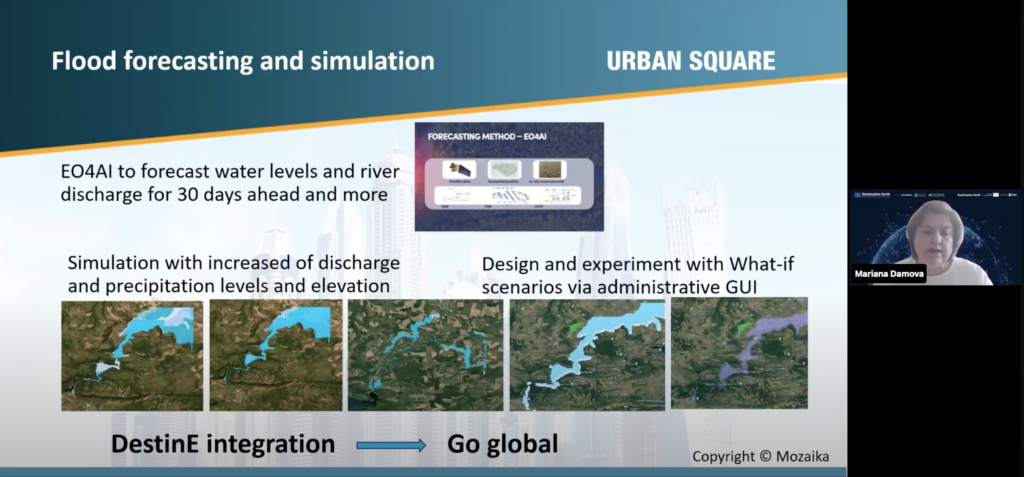
- Flood and Resources: Predicts and simulates floods by using EO4AI methods and increasing the water level, and river discharge along with precipitations, soil moisture, vegetation index from satellite data and applies them to digital elevation models to project the flood plains, identify the affected areas in terms of infrastructure, agriculture fields or buildings and assess the damages and needed resources
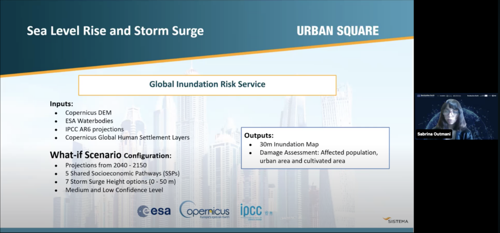
- Sea Level Rise and Storm Surges: Merges digital elevation models (DEMs) from Copernicus, ESAEuropean Space Agency Waterbodies layer and IPCC sea level rise projections. This integration enables detailed inundation risk assessments and projections.
One of the standout features of these Use CaseA practical scenario in which DestinE's capabilities are uti More is their ability to simulate “what-if” scenarios. This feature allows users to learn about the impacts of various climate risks under different conditions, such as varying levels of sea level rise or different meteorological factors. These simulations help planners make informed decisions about future policies and infrastructure investments, ensuring that urban areas are better prepared for climate-related challenges.
UrbanSquare’s integration with DestinE enables access to near real-time data, a significant improvement over traditional methods. For example, air quality data, which typically is released by national agencies with delays of several months, can now be accessed with a much shorter lag, allowing for more responsive urban planning and policy adjustments.
Beyond the use case
By simulating the impact of proposed policies such as green building standards or air quality regulations, UrbanSquare provides valuable feedback on their effectiveness and feasibility, as well as promoting inclusive, efficient urban development.
The integration with DestinE will promote knowledge sharing among urban planners, researchers and policymakers, letting users exchange best practices and innovative solutions on a grand scale.
Urban planners can fully harness the potential of UrbanSquare by experimenting with different scenarios and integrating its insights into their planning processes. Adopting a proactive and data-driven approach to urban planning is crucial to mitigate climate change and extreme weather events.
As urban planners and policymakers integrate this technology into their decision-making processes, cities around the world can better address the challenges of climate change and resilience, ensuring a safer and more sustainable future for their inhabitants.
Want to learn more? You can watch the recording of the UrbanSquare Roadshow Webinar now!