DestinE Pilot Service: Global Tide & Surge Forecast, Compound Flood Forecasting & Ship‑Route Optimisation
Enable three pilot services of global tide and surge forecasting, compound flood forecasting and early warning (Philippines), and global ship-route optimisation, integrates high‑resolution Weather-Induced Extremes Digital Twin forecast with DestinE infrastructure to enable real‑time forecasts as a service.
In a nutshell
Enable three pilot services of global tide and surge forecasting, compound flood forecasting and early warning (Philippines), and global ship-route optimisation
Integrates high‑resolution Weather-Induced Extremes Digital Twin forecast with DestinE infrastructure to enable real‑time forecasts as a service
Empower users of disaster management agencies and maritime operators with improved decision support for flood early warning and shipping routes planning.
Technical Overview
Challenge
Coastal communities face compound hazards from storm surges, waves, sea-level rise, and extreme precipitation, especially in areas where detailed local data is unavailable. Accurate, timely forecasts are essential for early warnings and disaster risk reduction. However, provide locally relevant flood forecasting anywhere in the world and integrating those into operational systems remains technically complex and computationally demanding.
Global shipping route planning must carefully balance navigation safety under changing metocean conditions—such as storms, waves —with the need to reduce fuel consumption and carbon emissions. By using high resolution weather and currents forecasting and automated route optimisation, vessels can navigate more safely while improving efficiency and lowering their environmental footprint.
DestinE Solution
The Global Tide and Surge Forecast pilot service aims to produce accurate forecasts for over 16,000 coastal segments and 40,000 locations globally. It combines data Extremes DT and Deltares’ Global Tide and Surge Model (GTSM) and the Global Storm Surge Information System (GLOSSIS). The service is particularly suitable for data-scarce regions, supporting early warning and disaster risk reduction in line with the United Nations’ Early Warning for All initiative.
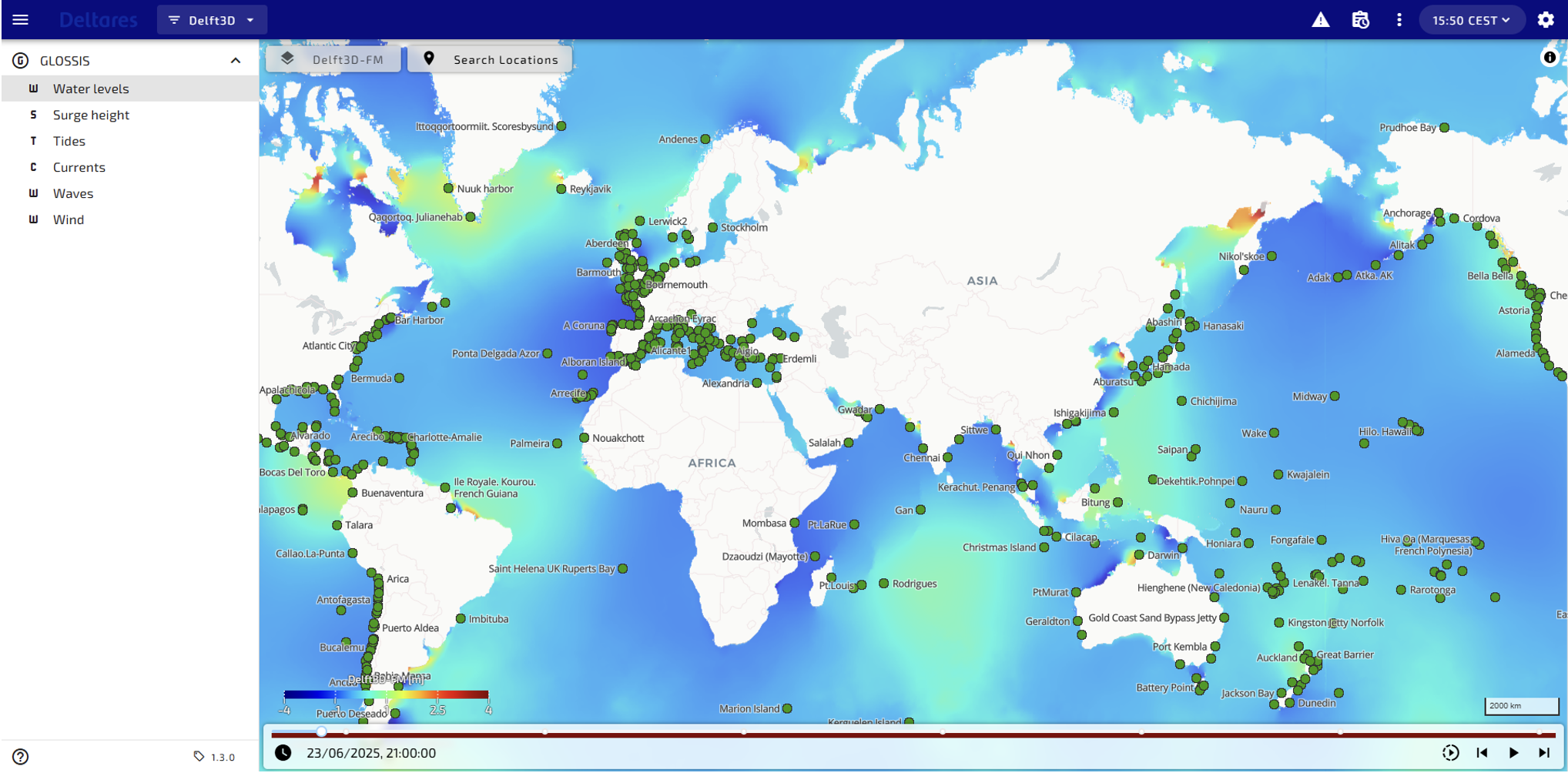
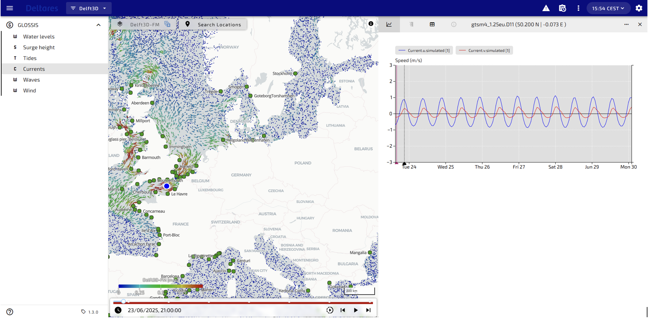
Figure 1 Example of GLOSSIS dashboard based on Delft-FEWS WebOC , the global total water level forecast includes both tide and storm surge (upper panel); Surface currents forecast near the English Channel (lower panel): spatial animation of surface currents forecasts (Left ), scalar time series of current speed at selected location (blue dot on spatial map, right )
The Philippines compound flood forecasting pilot service aims at providing flood forecasting and early warning for three flood prone areas in Philippines. This services integrate Deltares’ fast numerical compound flooding SFINCS enabling accurate compound flood forecasts, based on coastal water level computed by a nationwide coastal hydrodynamic model. This model is forced by GTSM at the open boundary and built based on Deltares software Delft3D FM. All models will be integrated into Deltares’ forecasting platform, Delft-FEWS, to ensure the timely generation of forecast information. Flood early warnings will be disseminated via 510`s Impact Based Forecasting (IBF) portal.
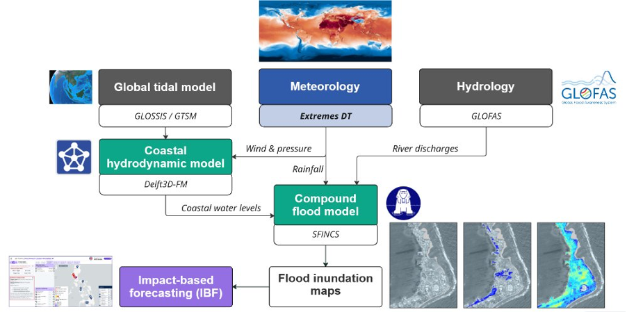
Figure 2 Compound flood forecasting and early warning workflow for Philippines pilot service
The Global Shipping Route Optimisation pilot service will integrate GTSM and Extremes DT forecasts into shipping route planning systems, MSG`s Navigator. With the enhanced data on forecast tides and weather conditions the shipping industry will be able to reduce their environmental footprint with more efficient routing and reduced risk of accidents.
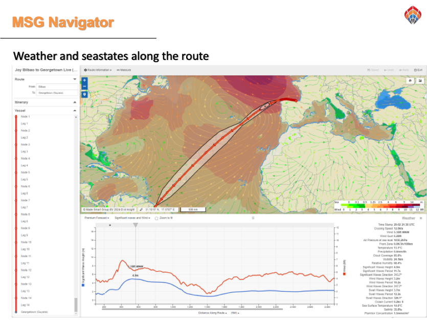
Figure 3 Optimised shipping routes provided by MSG Navigator
Impact
- Empowers disaster management agencies and maritime operators with improved decision support for flood early warning and shipping routes planning.
- Supports anticipatory flood early warnings and response in Philippines.
- Enhances maritime safety and reduce fuel consumption and carbon emissions for shipping industries.
- Demonstrates how coastal-climate extremes modelling and forecasting can be operationalised within the DestinE ecosystem.
- Demonstrates the added value of Extremes DT for flood forecasting and shipping routes optimisation.
Contributions
Providers
