Disaster Risk Mitigation & Climate Adaptation
Providing higher-resolution meteorological forecasts that can help address the challenges caused by compound flooding.
In a nutshell
- Compound flooding is the source of numerous challenges and it increases the likelihood of the independent hazard as tides, surge, waves, river discharge, precipitation as well as their co-occurrence amongst others due to changes in extreme events such as cyclones.
- Deltares, together with its partners KNMI, Tecnalia and 510 Red Cross, are working on setting up a digital twin that will support disaster risk reduction and climate adaptation.
- DestinE will provide a unique opportunity for higher-resolution meteorological forecasts and continuous streaming of climate projections that can contribute towards keeping people safe from flooding. The progress and results will be showcased through distinct case studies.
Technical Overview
Challenge
Climate change will result in sea level rise and changes in environmental conditions, such as changing rainfall patterns or marine physical conditions. At deltas around the world, where the river meets the sea, extreme events such as hurricanes may result in a phenomenon known as compound flooding.
Compound flooding refers to an event in which two or more flooding sources occurs simultaneously or in quick-succession, causing an amplified event that results in greater impacts. This phenomenon also poses unique challenges owing to the multitude of variables that contribute towards the hazard such as tides, surge, waves, river discharge, precipitation and extreme events such as cyclones.
To support better forecasting and disaster mitigation, higher resolution information is required to deliver information in a timely manner. A unique opportunity is provided by DestinE in that regard, as higher-resolution meteorological forecasts and climate projections can contribute towards keeping people safe from flooding, now and for the future.

DestinE Solution
Deltares, together with its partners KNMI, Tecnalia and 510 Red Cross, are developping a digital twin that will support disaster risk reduction and climate adaptation. A generic, globally-applicable modelling framework using open-source model components is being applied. Where needed, individual components are replaced or refined further using local models, thus, applying a “global to local” approach.
A total of five case study areas have been selected:
- Basque Country
- United Kingdom
- Philippines
- La Reunion
- Dutch Caribbean Islands (BES Islands)
The diversity in environmental conditions and user needs across the case studies helps in demonstrating the applicability of the service. For each case study area, an end-user is identified, who will provide iterative feedback to determine case-specific requirements.
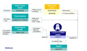
The overall modelling framework follows the same structure for all case study areas, see figure 1.2. The modelling chain exists of locally implemented models and global datasets for simulating the various physical processes. In general, the modelling chain exists of open-source model components from Deltares that can still be replaced by existing user-owned models. The modelling chain has been set up, with as final result flood inundation (water depth levels) translated into flood impact maps. The model implementations are similar for all regions. However, depending on the relevant flood drivers some model components may not be included in all workflows. The description of the type of models used for each physical process is described in the following sections.
For the Tier-1 dataset ERA5 was used as meteorological forcing and for each region together with the end-users an historic event was selected that resulted in severe flooding in the region. For the Tier-2 dataset climate and forecast datastreams from DestinE will be integrated. In addition, where available higher resolution, ensemble meteorological and hydrological forecast or hind-cast products will be used for uncertainty evaluation.
Modelling of the individual flood drivers
Tide and Storm Surge
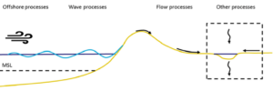
Sea levels comprise effects from astronomical tides, storm surges, wind waves and mean sea level variations, with each component operating on different spatial and temporal scales. Using the in-house Global Tide and Surge Model (GTSM see Figure 1‑3), which makes use of the Delft3D Flexible Mesh(FM) software, tide and storm surges are modelled using depth-averaged hydrodynamic models (2D). A flexible mesh refers to the unstructured nature of the grids used for modelling, allowing for spatially-varying resolutions and higher computational efficiency. As GTSM has a uniquely higher resolution along coastal areas (1-25-2.5km), this makes the software suitable for simulating extreme water levels in events such as tropical cyclones. The GTSM model is extensively validated (Muis et al., 2020; Dullart et al., 2020) and calibrated (Wang et al., 2021; Wang et al., 2022), demonstrating good performance for tide and storm surge simulations.
Waves
Ocean waves originate from the disturbance of the sea surface due to sustained winds, leading to the formation of a random wave field called the wind sea. The dispersion relation of waves governs their behaviour, causing waves with larger wavelengths to travel faster owing to the frequency dispersion. As these waves propagate through the ocean, the random wave field disintegrates, resulting in a decrease in directional spreading owing to directional dispersion. As a result, waves at a considerable distance from their source start t become regular and long-crested, moving in a coherent manner with similar frequencies, otherwise known as swells. The interaction of both sea and swell waves with slightly differing frequencies gives rise to a third wave type known as the infragravity wave. On the open ocean, infragravity waves exhibit very low heights.As waves approach the coastal environment, they interact with the increasingly shallow seabed topography and start to transform by shoaling, dissipating energy and transferring energy between various frequencies. This transformation largely affects the swell and infragravity waves, resulting in what is known as wave setup, which refers to the additional elevation of water levels from wave action. In general, wave setup is inversely proportional to the region available for wave breaking. Using the example of coastal areas that are lined with coral reefs, wave setup tends to be particularly large as waves have to break in a very confined area due to steep fore-reefs.
To account for wave setup, various models are used to capture the following parameters:
- Deep-water wave generation (using HurryWave)
- Generation of infragravity waves in the nearshore environment (BEWARE and VanOrmondt models)
- Nearshore setup of mean water levels (SNAPWAVE)
Wave model descriptions
HurryWave – Deep-water wave generation model developed by Deltares to simulate the generation and propagation of sea-swell waves by wind forcing. A third-generation spectral wave model similar to SWAN or WAVEWATCH-III, HurryWave is, on average, an order of magnitude faster than the SWAN model due to its very slightly reduced physics, combined with simpler wave propagation schemes.
SNAPWAVE – Another model developed by Deltares, SNAPWAVE is used to estimate nearshore wave setup within the SFINCS (Super-Fast Inundation of CoastS, described in later sections) model.
BEWARE (Bayesian Estimator of Wave Attack in Reef Environments) – A large synthetic database originally constructed based on approximately 100,000 1-Dimensional XBeach simulations, forced with a range of hydrodynamic conditions (Pearson et al., 2017). XBeach is an open-source model for simulating wave propagation, long waves, mean flow, sediment transport and morphological changes in the nearshore environment.
Van Ormondt (2021) leverages empirical formulations for sandy coastlines to approximate nearshore infragravity wave conditions. The empirical formulations were derived using 1-Dimensional XBeach-NH+ model runs for sandy profiles (XBeach Non-hydrostatic).
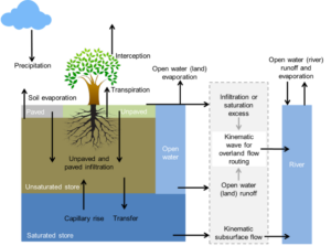
Hydrology
Hydrological processes play a pivotal role in the Earth’s water cycle, influencing the distribution and movement of water across the landscape. These processes encompass a wide range of phenomena, such as precipitation (rainfall), evaporation, infiltration, runoff and groundwater flow. Understanding and quantifying these complex interactions is crucial for effective flood forecasting. Mathematical models can be deployed to simulate these hydrological processes, enabling us to predict and prepare in advance during extreme events. Hydrological models can have a wide variety of complexity, from simple conceptual models to multi-dimensional gridded models.
Within this contract, the Wflow_sbm model will be used to predict discharge volumes and water levels. Wflow_sbm is a free and open-source distributed hydrological model that maximises the use of global and publicly available datasets. Models can be set-up in an automated fashion for river basins around the globe by using the Wflow plug-in within the HydroMT python package, which is also developed by Deltares. Wflow_sbm incorporates the processes included in Figure 1-4.
Flood inundation
Extreme events such as tropical cyclones may result in a flooding phenomenon where the impact of flooding may be amplified in certain coastal areas due to the simultaneous occurrence of multiple factors. These factors can include increased river discharge and increased coastal water levels due to tide, storm surge and wave setup. Having an Early Warning System (EWS) and a multi-hazard risk analysis in-place could help reduce these impacts by providing timely information for disaster preparedness. However, compound flooding is also challenging to predict due to large computational effort needed in short periods of time when considering the implications for early warning. Current modelling approaches have their own benefits and disadvantages, such as the ‘bathtub’ approach, which is extremely fast but too simplistic, and numerical models that achieve accuracy but lose out in speed, such as Delft3D or XBeach. As a compromise between these approaches, models that have reduced physical complexity can be deployed instead, resulting in much quicker computations due to the reduction in the number of equations to solve for.
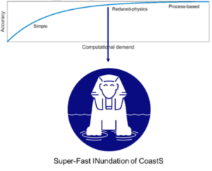
SFINCS (Super-Fast Inundation of CoastS) is one example of a reduced-physics model that is capable of simulating compound flooding with high computational efficiency, balanced with adequate accuracy (Figure 1‑5). Its efficiency makes it suitable for forecasting compound flood events in operational forecasting systems, and includes fluvial, pluvial, tidal, wind- and wave-driven processes (Figure 1‑6).
Flood impact
Floods can wreak devastating damages on buildings, services, mobility and may even lead to loss of lives. Modelling floods and potential damages can provide actionable information to decision makers, allowing them to prioritise or plan appropriate interventions on various timescales, such as between a few days (disaster preparedness) to decades in advance (climate adaptation). Delft-FIAT is a fast, open-source Python-based tool developed by Deltares to rapidly assess direct economic impacts to buildings, utilities and transport networks from user-input flood maps (Figure 1‑7). Delft-FIAT is made in a flexible manner, allowing a user to define their own damage functions, include other hazards, or even generate different damage classes.
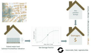
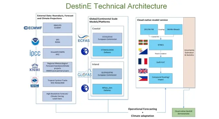
Figure 1.2: Schematic of DestinE Technical Architecture proposed within this project
Impact
Since July 2023, the Consortium has been busy preparing the Tier-1 datasets for the selected case study areas (Basque Country, Humber Estuary in the United Kingdom, BES islands, The Philippines and La Réunion). These Tier-1 datasets were delivered at the end of August. For all case studies the same technical modelling framework was consistently used and local extreme historical events were simulated. In the period August to December 2 rounds of meetings were organized with the end users to demonstrate and discuss the first prototype datasets and a round of improvements per region. We had nice brainstorms during online (La Reunion, United Kingdom) and live (Basque Country, Philippines) sessions with the end-users. Valuable feedback was provided on further improvements and possibilities for inclusion in existing operational routines. There was a visit from KNMI to Bonaire to present the new Dutch climate scenarios. During this visit the first results of the DestinE project were also shared in the forecasting room on Bonaire.
Foreseen activities for the coming months
In the coming months we will extend the current work with several activities working towards the Tier-2 datasets:
- We will improve specific models by including local high-resolution data, based on the end user requirements expressed during the progress meetings.
- We will conduct an uncertainty assessment for selected use cases by either replacing specific models from the generic model framework with local models (e.g. for the Humber and La Reunion) or with data from DestinationEarth (GLOFAS and others).
- We will extend the work in selected use cases to relate better to (1) DE Extremes by using high-res forecast datasets and (2) DE Climate Adaptation by using climate datasets and implementing WhatIf scenarios. To this end we will connect to the DestinE datastreams and data lake.
- We will further develop and the automatic implementation of the modelling framework and possibly test this automatization in another case-study area related to the other DE projects.
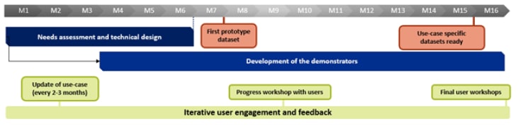
Figure 1.3: Timeline for the duration of the project
Contributions
The objective of this contract is to demonstrate the integration of regional coastal and inland models and local flood models in different regions, including in the Basque Country, the UK, La Reunion, the Dutch Caribbean Islands (BES Islands) and the Philippines, to manage compound flood risk. The regional models will use highresolution DT Extremes and in some cases also DT Climate data and configure transferable workstreams that provide actionable information to end users. The contract implements a co-design approach engaging local stakeholders in the design.
Providers
Learn More
For more information visit the ECMWF DestinE use case page on Disaster Risk Mitigation & Climate Adaptation.