Global Freshwater Availability
The HydroLand application is developed to provide high-resolution estimates for terrestrial freshwater availability, from global-to-local scale.
In a nutshell
- The HydroLand application is developed to provide high-resolution estimates for terrestrial freshwater availability, from global-to-local scale.
- The application makes use of the state-of-the-art hydrological model developed by Germany’s Helmholtz Centre for Environmental Research (UFZ) to calculate several variables related to freshwater availability like river discharge and soil moisture deficit.
- The information from this application provides insights into future flood and drought events.
Technical Overview
Challenge
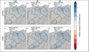
Climate change is affecting the hydrological cycle and exacerbating water scarcity worldwide. Such water-related disasters as torrential rains, droughts and floods have been increasing both in frequency and intensity. With the rising hydro-hazard impacts, decision-makers require an improved scientific basis for preparation and response to the future extreme hydrological events.
DestinE Solution
The HydroLand application makes use of the mesoscale Hydrologic Model (mHM), a well-established model used operationally by the German Drought Monitor developed by UFZ.
Additionally, the mHM is used operationally by ECMWF in delivering the Copernicus Climate Change Service (C3S) to provide global seasonal hydrological forecasts and has also served for research, among others, about the impacts of climate change in flooding and droughts in Europe.
The application consists of a “wrapping” software built around the mHM model that makes the interface with the climate DT and adapts the model to the global scale with the spatial and temporal resolution required.
The mHM has been coupled to the ClimateDT workflow as a hydrologic impact model. In general, the mHM model simulates the following processes: canopy interception, snow accumulation and melting, soil moisture dynamics, infiltration and surface runoff, evapotranspiration, subsurface storage and discharge generation, deep percolation and baseflow, and discharge attenuation and flood routing on a global scale. To represent these terrestrial hydrologic processes as accurately as possible, and to ensure a reliable performance in ungauged basins, this model employs a multiscale parameter regionalisation technique to obtain effective simulations at the scale of interest. The mHM model is driven by hourly or daily temperature and precipitation forcings.
Impact
The HydroLand application will provide variables and indicators on soil moisture dynamics, and their consequent impacts on crop yields. It is a successor to the HydroRiver application, which focused on providing variables and indicators related to run-off and river discharge. Within this phase, additional information like soil moisture deficits and drought indicators will be added to the service. Furthermore, this application will allow users to interact by providing separate set-ups for specific what-if scenarios. The what-if scenarios will be co-designed with the users and will focus on providing decision-ready information on the impact of water abstraction rates on drinking water availability, and the impact of land-use changes on crop yields.
Contributions
Providers
Learn More
For more information visit the ECMWF DestinE use case page on Global Freshwater Availability.